
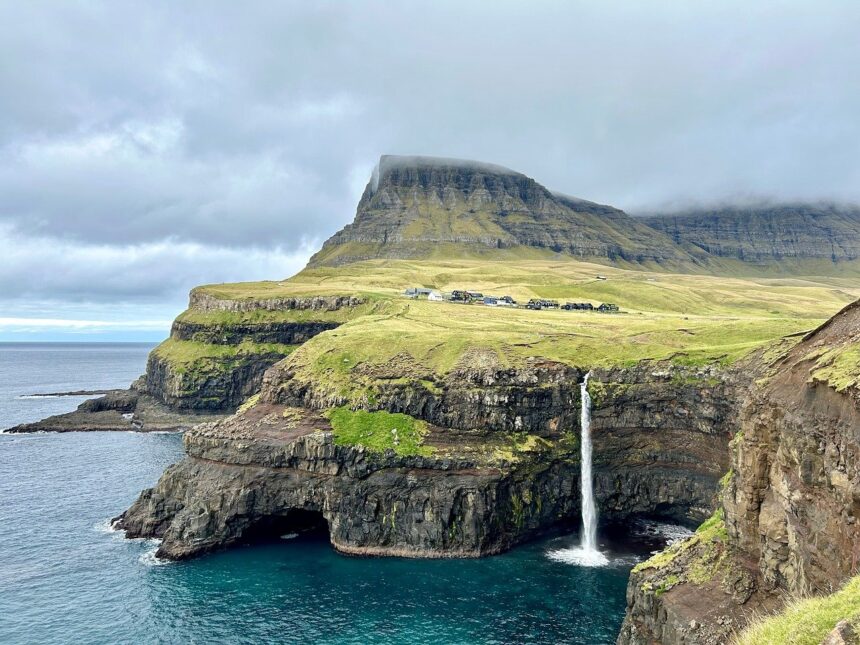
A lake in the Faroe Islands creates a persistent optical illusion that makes it appear to hover above the Atlantic Ocean — the product of cliff geometry, elevation, and viewing angle, not magic.
Sørvágsvatn, also known as Leitisvatn, sits 105 feet (32 meters) above sea level on the island of Vágar. According to the report, the illusion is only visible from a limited number of angles near the lake’s southern tip, where the cliff face slopes slightly inland. From a position several hundred feet out, the shoreline appears to reach the cliff edge directly, making the water look as though it extends out over the sea.
The lake covers 1.3 square miles (3.4 square kilometers) and drains into the Atlantic through Bøsdalafossur, a waterfall standing 100 feet (30 meters) high. Surrounding cliffs amplify the visual effect, making the water appear even higher above the waves than its actual elevation.
Two Names, One Lake
The illusion is not the only thing about the lake that defies easy resolution. Locals cannot agree on what to call it.
Residents of Sørvágur, a village to the west, use Sørvágsvatn — meaning “the lake by Sørvágur.” Those in the eastern villages of Miðvágur and Sandavágur prefer Leitisvatn, or “the lake by Leiti,” a reference to an eastern territory of the Faroe Islands.
The dispute has historical weight. Sørvágur is believed to have been settled earlier, during the ninth century, even though Miðvágur sits closer to the water. A separate argument for the Sørvágsvatn name draws on the Faroe Islands’ original settlement pattern: the first settlers divided Vágar into three equal regions, and the lake falls within the same region as Sørvágur.
To sidestep the argument entirely, locals largely default to calling it Vatnið — simply “the lake.”
What Produces the Illusion
The effect depends on a specific set of conditions aligning. The cliff does not drop vertically from the lakeshore but angles slightly away from the water, meaning the true edge of the land is hidden from certain vantage points. The observer’s eye connects the waterline to the cliff top as a single continuous surface — one that appears to be suspended over open ocean.
The waterfall Bøsdalafossur, named for the area near the settlement of Bøur, marks the lake’s primary outlet and sits at the center of the most dramatic viewing angles. The cliffs flanking it on both sides reinforce the sense of height.
The lake is located at coordinates 62.0496, -7.2362 on Vágar, the island that also hosts the Faroe Islands’ main airport.
Photo by Pixabay
This article is a curated summary based on third-party sources. Source: Read the original article